
Mowbray | Craiglie
South of Port Douglas lies the Mowbray Valley, in the foothills of the Macalister Range and the Wet Tropics Mowbray National Park.
The Mowbray Valley was the hunting ground for the Chabbuki (Tjapukai) Indigenous people. They moved through the valley on hunting trips between Port Douglas and Mona Mona camp near Kuranda. Their name for the area south of, and adjacent to the river was Chungamya.
The historic 'Bump Track' can be accessed here, open to walkers, mountain bikers and horses and traverses Mowbray National Park between the coastal lowlands and Black Mountain Road.
Craiglie was a teamsters' camp four miles from Port Douglas, where they prepared their vehicles and animals to climb the steep Bump Track. Now it is a small industrial area with two service stations on the main highway, although the Australian Bureau of Statistics also includes areas north to the Port Douglas State School.
The population lives around the Mowbray River, Spring Creek and Oak Beach.

Bridge over Running Creek (Robbins Creek) on the "bump" road three miles from the bottom.
1842-1845
Between these years, Charles Yule commanded the Bramble and travelled with Capt Francis Blackwood on the Fly, passing this coast.
1848
Yule Point was named for Lieut. Charles Bampfield Yule, commander of the Bramble, on its voyage with HMS Rattlesnake, commanded by Capt Owen Stanley.
1876
Mar / James Venture Mulligan discovered new goldfields on the Hodgkinson River, but access to the coast was difficult.
1877
Apr / Christie Palmerston and his mate William C. Leyton (sometimes inaccurately named Lakeland or Little) and their aboriginal guide Pompo discovered a route suitable for wagons and pack teams from the Hodgkinson goldfield down to White Cliffs near Island Point, which would become Port Douglas. Their route over the range down into the river valley was called the Bump Track because of its steep grades. Palmerston named the river that had led them down the range after the Goldfield Warden for Thornborough, William Matthew Mowbray. They carved their initials ‘CP/WL 1876’ on the Mahogany tree they camped under at Mowbray.
May / W.O. Hodgkinson, Warden of the field that Mulligan had named after him, traversed Palmerston’s route and made an official complimentary report dated 11 June.
Jun 16 / William Bairstow Ingham’s boat S.S. Fitzroy with 9 passengers from Cairns got into Palmerston’s Mowbray River on a high tide and found the tree emblazoned with the initials CP/WL and a few prospectors’ tents.
Jun 17 / The Fitzroy sailed out on the next high tide from Mowbray River to Island Point. From that time all the shipping made port at Island Point.
Jul 11 / After the Bump Track had been widened, Moss of Kingsborough brought the first pack team through to Hodgkinson, leaving Port Douglas on Wednesday and arriving Sunday.
Aug 3 / John James Montgomery applied for the first homestead selection No.23 of 160 acres on the Mowbray River.
Sep 6 / The 'Bump Road' (Palmerston’s track) was opened which provided access to the goldfields. The Bump Road ran from Port Douglas to Rifle Creek, near the future Mount Molloy township. Thirty teams, the first to traverse the "Bump", came down the road from the Hodgkinson in convoy.
Oct / The first large mining machinery was despatched to the Beaconsfield Mine up the Bump on two wagons.
Nov / Rudolf Berzinski selected 160 acres just outside the 6-mile boundary of Port Douglas, at Craiglie. He was a pioneer settler of Mowbray. Grandson Ernie was chairman of the Douglas Shire Council for 9 years.
1877-1893
The area between Spring Creek and Yule Point was known as ‘The Police Camp’ where all the men and horses for the Mounted Police and Gold Escort from the Hodgkinson goldfields were located.
1878
A Road Board was established and improvements made to the Bump Road. Four Mile Camp, later named Craiglie (Craiglea or Craiglee), was set up as a packers’ and teamsters’ village. Richard and Margaret Ryan owned Ryan’s hotel and the other premises was known as Ruggs’ Hotel.
1879
Telegraph communication began
1880
John James Montgomery, with his partner John (Jack) George Robbins, a butcher, built Mayfield between the Mowbray River and the Spring Creek junction, the pick of the land at the time. They grew fodder, rice, citrus and fruits, supplied to the teamsters. They had Chinese tenants. In later years Robbins acquired a mowing machine drawn by two horses to keep weeds under control.
John Trezise, a Cornishman known as Cornish Jack, settled at Spring Creek, growing citrus, rice, maize, a jackfruit tree with huge fruit, then cane. Trezise Road is named after him. He died in 1910 aged 74.
Early 1880s
John Pringle arrived from South Queensland and built a house at Craiglie. His five sons and one daughter went to Craiglie school. His property in South Mossman, Fairymount, was being developed should a sugar mill be built
1881
Seven miles from Port Douglas the road crossed the Mowbray River where another small roadside settlement sprang up around Gregory’s Hotel. More packers and teamsters’ homes and another blacksmith shop provided the needs of the transport service. A mile further on was the start of The Bump.
Jabez Gregory was licensee of the Mowbray Hotel.
1882
James Reynolds selected Portion 154, Mowbray Vale, with wife Margaret, nee Logue. He grew cattle, maize, fruit and sugar cane. He opened a butcher’s shop at Craiglie.
Patrick Reynolds, brother of James, took up Portion 209. He owned the Range Hotel nearby and wife Bridget held the licence from 1885-1893. Patrick died of a stroke in 1886.
Reynolds Park in Port Douglas is named for the pioneering family.
c1884
Bill Millet, a pioneer coachman, selected land called The Grange and built up a citrus orchard. He had a Chinese tenant. They made their fruit cases from split palings with a tomahawk. Sawn timber was not available. Bill bought a two-horse-power kerosene engine and a circular saw to make his cases. He also supplied burnt lime to the Mossman Mill for the manufacture of raw sugar.
Allan McDougall Gray was an early selector of a large portion at Spring Creek and moved there with wife Margaret. He installed a geared machine which operated a three-blade chaff cutter. Oats and other herbage were grown on this farm and was cut into chaff for the teamsters.
1885
With the introduction of the Pacific Islanders Act, no Kanakas were to be imported after 1890. This would deal a severe blow to the sugar industry so the Act was amended and extended until 1900. Land was owned by the whites but cleared and worked by Chinese, Hindu, Punjabi, Japanese and Kanaka labour. No Kanakas were allowed into Australia after 1904
1886
Coffee was grown at the Seven Mile by Chinese, as well as rice which paid better than fruit or maize.
1888
Mar 26 / Craiglie Provisional School opened with 27 children and teacher Bridget Anna Lawless. It became a State School in Feb. 1890.
1890
James Reynolds’ citrus and mango orchard had 2400 trees. He also grew maize and sweet potatoes and had a herd of milking cattle.
1891
When the Cairns railway was completed to Myola, just beyond Kuranda, the importance of Craiglie for the “Knights of the Road”, the teamsters, ended.
William McEdward Stewart and family settled at Spring Creek, portion 43, on property originally selected by Allan Gray. On the property there was a fine orchard and Chinese tenants, Lee Hon and Lee Mew or Mow.
Early 1890s
Severin Berner (Barney) Andreassen settled in the Mowbray Valley and worked on the railway, finally building bridges, cutting cane and fishing for beche-de-mer from Schnapper Island with his partner Daniel Moynahan. He was Councillor and Chairman of the Shire. He died in 1937 at an Edge Hill railway crossing while visiting his old friend Capt Moynahan. A plaque to his memory is on the top of what used to be called Billy Goat Hill, now Flagstaff Hill in Port Douglas.
1892
The police reserve depot closed. It was on the northeast side of Spring Creek and the gold escort horses were kept there. There was accommodation for the officer in charge and family, and about 20 aboriginal troopers.
1893
The railway between Cairns and Mareeba was opened with the result that the Bump Track became used only for passenger traffic rather than predominantly for freight as it had been. Craiglie soon became a deserted village.
1894
The single storey galvanised iron hotel Ryan’s at Craiglie was moved to Front Street Mossman by George Kearsley and renamed the Mossman Hotel.
1896
Tick Fever, or Redwater, appeared in cattle herds of the district. About 90% of the cattle died within a month. John Robbins, of Lower Mowbray Valley, procured a Brahman bull from Melbourne Zoo in an endeavour to build up a strain of tick resistant cattle. The locals called them Zebus. The progeny of this bull was the forerunner of the Brahman stock through the north.
William Stewart started rearing goats, skins were a good price, but the idea was a failure and the goats took to the precipices. Dingoes got the lot.
1897
Fred Jensen bought Mullavey’s Mowbray Hotel at Mowbray River Crossing and moved it to Mossman to become the Royal Hotel.
1902
Jan / An extension to the cane tramway connecting Mowbray to the Mossman Central Mill was opened. The journey to Mossman took 1 hour 26 minutes. The sugar mill had opened there in 1897. The Mowbray terminus was the Mowbray Post Office. The stop before was called Ballyhooley.
1904
20,000 cases of oranges and mandarins were shipped out annually from the Port Douglas wharf, most coming from the Mowbray Valley
1906
Mar 7 / William Allen married Charlotte (Lottie) Berzinski at her residence in Craiglie. In William’s boyhood he worked with his father on Cobb and Co coaches going over the Bump to Herberton. William and Lottie farmed at Mowbray together for 49 years.
1907
James Patrick Reynolds, second son of James and Margaret, took up a selection adjoining the home farm and grew sugar cane until he retired in 1947. Feb 1906 was the last season for coloured labour on the cane fields so James recruited a gang of white cane cutters, among them six Connolly brothers from New South Wales. Three of the brothers married three of James’s sisters and stayed on to acquire land and grow cane in Upper Mowbray.
1911
Mar 16 / A cyclone devastated the area, the second “blow” within 5 weeks. The Stewart family home was flattened and they moved to a temporary shack. The Mowbray branch of the tramway was badly damaged. Six spans of the Mowbray River bridge were washed away.
Apr / A large flood washed away the Trezise home at Spring Creek and their outbuildings and half of their citrus orchard.
A Methodist Church was built near the top of Robbins Hill by Mr Fred Stevenson. It was later re-erected as a hall at the rear of the Methodist church in Mossman
1913
James Patrick Reynolds, son of James was Chairman of the Douglas Shire Council 1913 - 1920. He father had been Chairman when the Divisional Board became the Shire Council in 1901.
1915
A severe drought made the fallen timber from the 1911 cyclone very dry and bushfires burnt kauri pine and hickory. Farmers in Spring Creek spent a week trying to put out a fire.
1917
Rosebank house was built by Billy Burdett, assisted by Matt and Michael Connolly, from timber from the property sawn at Billy’s sawmill. William Thomas Burdett had married Helen Mary Thomson, (born 1880) daughter of Ellen Thomson, in 1900.
1918
Jan 18 / Harry Baird was driving a buckboard drawn by two horses from Mt Carbine to Port Douglas, the passengers were his mother Mrs Carr and Mick Bonner. In the back seat were Renie Bair aged 11 and Nonie Edwards aged 12. They were caught in a wall of flood water at the Mowbray crossing and Nonie drowned.
1919
Jun 6 / It was mooted by Douglas Shire Council to build Anzac Bridge (later called Diggers Bridge) over the Mowbray River with unemployed returned soldiers. No date of completion can be found but it was finished by 1923.
1920
Mar / A severe cyclone struck the valley damaging most houses and many mango trees.
Early 1920s
The Bump Track was used by cars and buses which were helped up the very steep places by teams of horses. James Patrick Reynolds, who lived at the foot of the Track, supplied the horses.
1923
The War Memorial in Anzac Park was unveiled by Mrs Trezise, mother of the first Port Douglas soldier to be killed in the Great War.
1925
Most of the aborigines of the Mowbray area had gone to Mona Mona Mission Station near Kuranda where they had permanent shelter and food provided by the Mission.
The Hockley Telephone Exchange began operation from the Burdett household and continued for many years.
May 20 / The Mowbray School opened at 264 Mowbray River Road with Mr. Alexander Larcombe ‘Bunny’ Edward as teacher for 13 pupils.
1928
Jul 22 / The Craiglie School closed. Mrs Ethel Taylor, the teacher, transferred to the new Killaloe school which opened on 23 July and closed on 12 July 1935.
1929
During the Great Depression, hundreds of unemployed men came to the district. The Ballyhooley tramway goods shed was a popular stopover place
1932
With the coming of cars, tram traffic fell off and tram services to Mowbray were discontinued and other timetables were reduced.
1933
The use of the Bump declined after the opening of the Cook Highway between Cairns and Mossman.
May 21 / Frederick William (Bill) Hardwick married Ethel Ramsay. He had taken up land in Mowbray and named it Glengarry. His family had migrated from Hockley, Essex, England.
1934
Mar 12 / A cyclone crossed the coast near Rocky Point. A tidal surge reached three feet over the newly constructed road at Pebbly Beach
A very large flood washed away a substantial strip of Michael Connolly’s land. The same flood cut a new channel through Matt’s Connolly’s best paddock called The Island, ruining it completely.
Aug 1 / A Toll was introduced on the Cairns road and remained in force until 1947.
1942-1945 (WW II)
The Bump was mined in two places by the army and in the event of an invasion James Reynolds. Sons Jim and Matt who were members of the local Home Guard, were instructed to blow up the road. The explosives were removed by the army in 1946.
The Mowbray School closed for two years during the war when there were only two pupils.
1949
Thomas and Mabel Larkin and Kenneth Stanley Warland drew blocks in the Soldiers’ Settlement Scheme ballot near Oak Beach at the foot of Mount Garioch. In 1971 Tom sold his block to Robert Prettejohn who developed Thala Beach Resort.
1950s
The Hockley telephone Exchange was located at the Hume residence on the bank of Spring Creek. Elizabeth Trezise, daughter of John, had married John Hume who advocated for the establishment of Mowbray school.
1961
Dec 31 / Mowbray River State School closed with 8 pupils The School building was put up for auction in 1963 to be used as a private house.
1963
Ernie Berzinski, grandson of Rudolph, was Chairman of the Douglas Shire Council and went to Melbourne to greet the coach from the Cobb and Co re-enactment with King Diamond, the official representative of the Aboriginal people of the shire.
1977
A memorial, which paid tribute to all of the teamsters, packers and their untiring transport animals, was erected in Craiglie to recognise the centenary of Palmerston's exploration achievement which directly led to settlement here.
1980s
Toll Gate Road at Pebbly Beach was named by Douglas Shire Council.
1990
Jan 26 / Brian and Kathy Berzinski opened Glengarry Holiday Park. The family bought the land in 1967 from Mr and Mrs Hardwick.
1996
“Paradise Road” a feature film about women prisoners of war in Sumatra, was filmed at Mowbray, starring Glenn Close, Cate Blanchett and Frances McDormand, directed by Bruce Beresford.
1998
May 20 / Robert and Oonah Prettejohn opened the eco retreat Thala Beach Nature Reserve.
2000
Sep 8 / The locality of Oak Beach was named and bounded.
2016
Census : the population of Mowbray was 321, Oak Beach 195 and Craiglie 954.
2017
Oct / Police feared that a grandmother who wandered away from her care home for the elderly in far north Queensland has been taken by a crocodile. Clothing believed to have belonged to the missing pensioner had been found beside a small creek near the Mowbray River.
2018
Jul / Douglas Shire Council persuaded the State government to preserve the old Diggers Bridge. Strident local opposition to the plan to build a new two-lane bridge nearby resulted in the removal of five or six raintrees lining the waterway. A pile from the original bridge is on display at Craiglie Teamsters Park.
Compiled by Pam Willis Burden with Gail Cockburn in March 2022.

Unidentified (1895) Christie Palmerston. John Oxley Library, State Library of Queensland
Christie Palmerston’s route
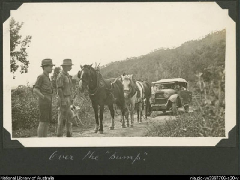
Two men look on as a car and its passengers are hauled up the Bump Track by three horses, Port Douglas Region, Queensland, c1928 Part of Great Barrier Reef Expedition, 1928-1929

J. P. Reynolds' team of horses pulling a car to the top of Slatey Pinch on Bump Road, c 1930

Running Creek

Mowbray River bridge 1911 cyclone damage

Faugh a Ballagh on Mowbray River bridge 1957 towards the end of Douglas Shire Council tramway operations. Alwyn Fielding, Reg England and Jack Wolfe

Mowbray School (date unknown)

Craiglie “Four Mile” School

Diggers Bridge in Mowbray


Access to the Bump Track today